MAKE A MEME
View Large Image
| View Original: | 1852_Levasseur_Map_of_the_Department_De_La_Loire_Inferieure,_France_(Muscadet_Wine_Region)_-_Geographicus_-_LoireInferieure-levasseur-1852.jpg (3500x2575) | |||
| Download: | Original | Medium | Small | Thumb |
| Courtesy of: | commons.wikimedia.org | More Like This | ||
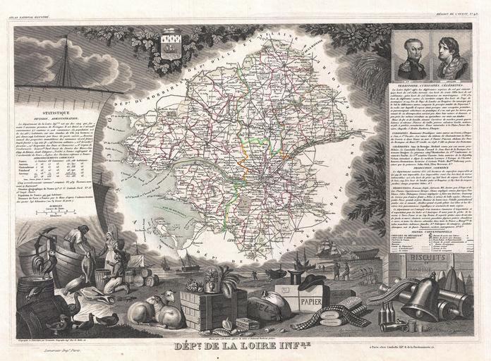
| Keywords: 1852 Levasseur Map of the Department De La Loire Inferieure, France (Muscadet Wine Region) - Geographicus - LoireInferieure-levasseur-1852.jpg This is a fascinating 1852 map of the French department of Loire Inferieure France currently known as Loire-Atlantique This area of France is part of the Loire Valley wine region and is especially known for its production of Muscadet a white wine produced from the Melon de Bourgogne grape variety This area is also famous for a variety of cow ™s milk cheese known as Fromage du CurĂ© Nantais The map proper is surrounded by elaborate decorative engravings designed to illustrate both the natural beauty and trade richness of the land There is a short textual history of the regions depicted on both the left and right sides of the map Published by V Levasseur in the 1852 edition of his Atlas National de la France Illustree 1852 undated Size in 17 12 object history credit line accession number LoireInferieure-levasseur-1852 Levassuer V <i>Atlas National Illustre des 86 Departements et des Possessions de La France Divise par Arrondissements Cantons et Communea avec La Trace de Toutes Les Routes Chemins de fer et Canaux </i> 1852 edition Geographicus-source PD-old-100 1852 maps France Old maps of Loire-Atlantique Coats of arms of Nantes Pierre Cambronne Peter Abelard Fishermen in art Maps in French France Victor Levasseur - Maps of France France Muscadet AOC | ||||
_-_Geographicus_-_LoireInferieure-levasseur-1852.jpg)