MAKE A MEME
View Large Image
| View Original: | 1852_Levasseur_Map_of_the_Department_Du_Cantal,_France_(Cantal_Cheese_Region)_-_Geographicus_-_Cantal-levasseur-1852.jpg (3500x2525) | |||
| Download: | Original | Medium | Small | Thumb |
| Courtesy of: | commons.wikimedia.org | More Like This | ||
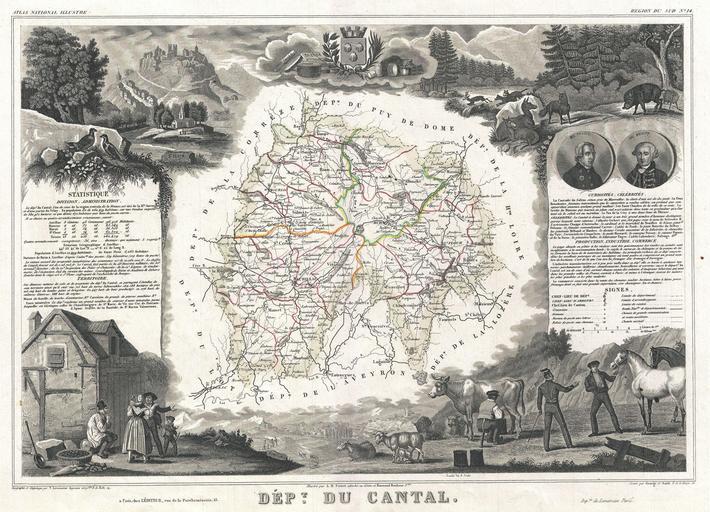
| Keywords: 1852 Levasseur Map of the Department Du Cantal, France (Cantal Cheese Region) - Geographicus - Cantal-levasseur-1852.jpg This is a fascinating 1857 map of the French department of Cantal France This area of France is known for its production of Cantal a firm cheese named after the region The whole is surrounded by elaborate decorative engravings designed to illustrate both the natural beauty and trade richness of the land There is a short textual history of the regions depicted on both the left and right sides of the map Published by V Levasseur in the 1852 edition of his Atlas National de la France Illustree 1852 undated Size in 16 5 12 object history credit line accession number Cantal-levasseur-1852 Levassuer V <i>Atlas National Illustre des 86 Departements et des Possessions de La France Divise par Arrondissements Cantons et Communea avec La Trace de Toutes Les Routes Chemins de fer et Canaux </i> 1852 edition Geographicus-source PD-old-100 Victor Levasseur - Maps of France France 1852 maps France Old maps of Cantal Aurillac coat of arms Dominique-Dufour de Pradt Pierre Laurent Buirette de Belloy Milking in art Saint-Flour Cantal view of city | ||||
_-_Geographicus_-_Cantal-levasseur-1852.jpg)