MAKE A MEME
View Large Image
| View Original: | 1852_Duvotenay_Map_of_the_United_States_(Gold_Rush)_-_Geographicus_-_EtatsUnis-duvotenay-1852.jpg (3000x2192) | |||
| Download: | Original | Medium | Small | Thumb |
| Courtesy of: | commons.wikimedia.org | More Like This | ||
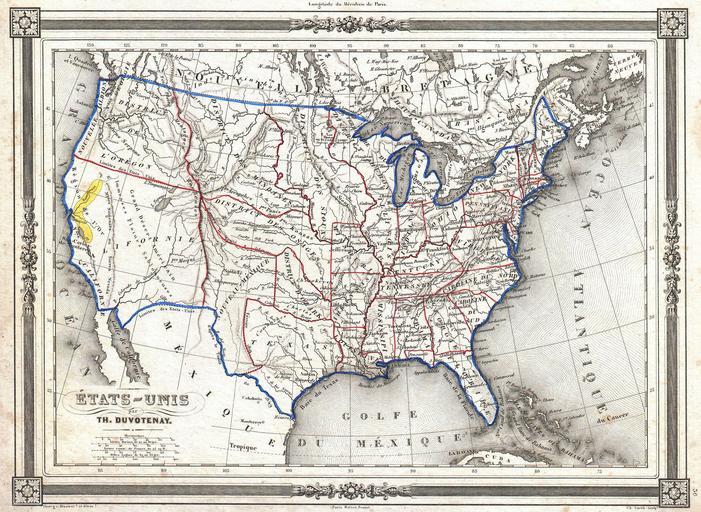
| Keywords: 1852 Duvotenay Map of the United States (Gold Rush) - Geographicus - EtatsUnis-duvotenay-1852.jpg An uncommon and extremely attractive 1852 map of the United States by Th Duvotenay Depicts the United States at the height of the California Gold Rush and shortly after the annexation of Texas While most of the eastern United States is well defined the territories of the transmississippi west are somewhat vague California is shown as the large territory ceded by Mexico in 1849 The gold region along the Sacramento River is colored yellow and notated Nouveau-Mexique New Mexico appears on the map in a very early state with its capital at Santa Fe Encompassing much of the territory that is traditionally included as part of the c 1850 Texas especially the northern extension along the Green River; it is bounded on the west by the Rocky Mountains the north by the Arkansas River and the east by Texas along the line established by the Adams-Onis treaty of 1819 Texas appears in an unusual configuration separated its c 1850 western properties by the Adams-Onis treaty line To the north of Nouveau-Mexique and Texas Several American Indian territories are shows including the District des Mandanes the District des Osages the District d ™Ozark and the District Des Sioux Labels the Great Salt Lake as Lake Teguayo after JosĂ© Antonio de Alzate y RamĂrez Lake Teguayo is said by some to be the legendary homeland of the Aztecs To the north of Lake Teguayo today ™s Lake Utah is labeled Lake Timpanogos Features a beautiful frame style border Prepared by Th Duvotenay for publication as plate no 30 in Maison Basset ™s 1852 edition of the Atlas Illustre 1852 undated Size in 12 5 9 object history credit line accession number EtatsUnis-duvotenay-1852 Maison Basset <i>Atlas Illustre</i> 1852 issue Geographicus-source PD-art Old maps of the United States Thunot Duvotenay 1852 maps Maps in French California Gold Rush | ||||
_-_Geographicus_-_EtatsUnis-duvotenay-1852.jpg)