MAKE A MEME
View Large Image
| View Original: | 1850_Mitchell_Map_of_South_Carolina_with_Charleston_inset_-_Geographicus_-_SouthCarolina-mitchell-1850.jpg (3500x2873) | |||
| Download: | Original | Medium | Small | Thumb |
| Courtesy of: | commons.wikimedia.org | More Like This | ||
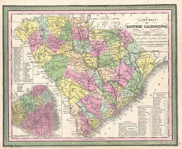
| Keywords: 1850 Mitchell Map of South Carolina with Charleston inset - Geographicus - SouthCarolina-mitchell-1850.jpg A fine example of Samuel Augustus Mitchell ™s important 1850 map of North Carolina This map shows cities topographical features railways ferries and roads with color coding at the county level In addition to cartographic information this map is full of practical data for the traveler including notes on steam boat and ferry routes The lower left quadrant bears a detailed inset of Charleston divided into its five goroughs Cannon Radcliffe Wragg Mazyck and Hampstead Important buildings streets wharves and piers are also noted Cartographically this map is based on the earlier work of Tanner though it has been updated with new information as well as Mitchell ™s distinctive decorative border and color scheme Published as plate no 19 in the 1850 edition of Mitchell ™s New Universal Atlas Dated and copyrighted Entered according to Act of Congress in the year 1850 by Thomas Cowperthwait Co in the Clerk ™s Office of the District Court of the Eastern District of Pennsylvania 1850 dated Size in 15 12 5 object history credit line accession number SouthCarolina-mitchell-1850 Geographicus-source PD-old-100 Maps by Samuel Augustus Mitchell Old maps of South Carolina 1850 maps Old maps of Charleston South Carolina Maps in English | ||||