MAKE A MEME
View Large Image
| View Original: | 1846_Street_Map_or_Plan_of_Philadelphia,_Pennsylvania_-_Geographicus_-_Phili-m-1846.jpg (2415x3000) | |||
| Download: | Original | Medium | Small | Thumb |
| Courtesy of: | commons.wikimedia.org | More Like This | ||
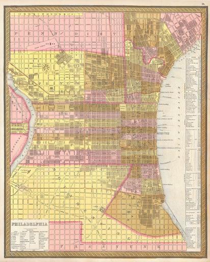
| Keywords: 1846 Street Map or Plan of Philadelphia, Pennsylvania - Geographicus - Phili-m-1846.jpg This scarce hand colored map is a lithographic plan or map of Philadelphia dating to 1846 by the legendary American Mapmaker S A Mitchell the elder Depicts the entire city in stupendous detail with even important buildings streets piers and canals drawn in This is a rare transitional map produced by the mysterious engraver H N Burroughs whose work for the Mitchell firm appears in 1846 between that of H S Tanner and Mitchell himself Ristow notes Nothing is known about Burroughs but he was undoubtedly an employee or associate of Mitchell His fine and detailed work appears only in the hard to find 1846 edition of the Mitchell ™s Atlas and evinces a more delicate hand than later editions Dated and copyrighted 1846 1846 Size in 16 13 object history credit line accession number Phili-m-1846 Geographicus-source PD-old-100 Maps by Samuel Augustus Mitchell 1846 maps Old maps of Philadelphia | ||||