MAKE A MEME
View Large Image
| View Original: | 1846_Burroughs_-_Mitchell_Map_of_Ohio_-_Geographicus_-_Ohio-m-1846.jpg (2854x3500) | |||
| Download: | Original | Medium | Small | Thumb |
| Courtesy of: | commons.wikimedia.org | More Like This | ||
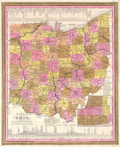
| Keywords: 1846 Burroughs - Mitchell Map of Ohio - Geographicus - Ohio-m-1846.jpg This scarce hand colored map is a lithographic engraving of Ohio dating to 1846 by the legendary American Mapmaker S A Mitchell the elder Includes a detailed inset map of Cincinnati Along the bottom there is a profile of the Ohio Canal with navigational notes This is a rare transitional map produced by the mysterious engraver H N Burroughs whose work for the Mitchell firm appears in 1846 between that of H S Tanner and Mitchell himself Ristow notes Nothing is known about Burroughs but he was undoubtedly an employee or associate of Mitchell His fine and detailed work appears only in the hard to find 1846 edition of the Mitchell ™s Atlas Dated and copyrighted 1846 1846 Size in 14 11 5 object history credit line accession number Ohio-m-1846 Geographicus-source PD-old-100 Maps by Samuel Augustus Mitchell Old maps of Ohio 1846 maps Maps of Cincinnati Ohio Ohio and Erie Canal Canal and dam-related diagrams | ||||