MAKE A MEME
View Large Image
| View Original: | 1843_Monaldini_Case_Map_of_Rome,_Italy_-_Geographicus_-_Rome-monaldini-1843.jpg (6000x4350) | |||
| Download: | Original | Medium | Small | Thumb |
| Courtesy of: | commons.wikimedia.org | More Like This | ||
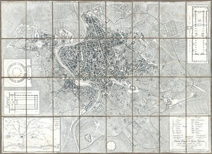
| Keywords: 1843 Monaldini Case Map of Rome, Italy - Geographicus - Rome-monaldini-1843.jpg A fine and rare 1843 case format map of Rome Italy by Venanzio Monaldini This extraordinary map of Rome heavily references with various updates and revisions the seminal 1734 map of Rome by Giovanni Battista Nolli Nolli ™s map was the first modern map of Rome and basis of almost all subsequent maps of Rome until approximately 1870 when Rome became the capitol of Italy and more modern plans were issued Depicts the city in extraordinary detail labeling all streets ferry crossings bridges parks and historic buildings Surrounded by plans of important buildings including the Mausoleum of Saint Constance the Basilica of St Paul a layout of the Pantheon and the floor of the Church of Saint Lorenzo In the lower left quadrant there is a map of the vicinity of Rome In the lower right quadrant there is a text box with a list of the 14 neighborhoods of Rome along with the map's title and publication information This map was designed with the traveler in mind and thus bisected and backed with linen for easy folding Comes with original slipcase Most likely engraved by Pietro Ruga a prominent Rome based engraver best known for his architectural plans and views Published from Venanzio Monaldini ™s bookshop on 79 Piaza di Spagna Rome Italy 1843 undated Size in 34 24 5 object history credit line accession number Rome-monaldini-1843 Geographicus-source PD-art Old maps of Rome 1843 maps 1843 in Rome Maps in Italian | ||||