MAKE A MEME
View Large Image
| View Original: | 1838_Wyld_Wall_Map_of_India_(Hindostan_or_British_India)_-_Geographicus_-_India-wyld-1838.jpg (5000x6111) | |||
| Download: | Original | Medium | Small | Thumb |
| Courtesy of: | commons.wikimedia.org | More Like This | ||
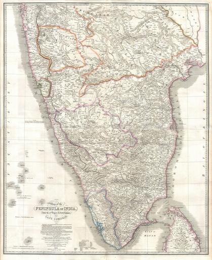
| Keywords: 1838 Wyld Wall Map of India (Hindostan or British India) - Geographicus - India-wyld-1838.jpg This stunning wall map of India dating to 1838 is James Wyld's reissued of William Faden's important c 1799 map of the same region This is one of the largest and most impressive maps of India to emerge in the 19th century This chart depicts the subcontinent from Bombay Mumbai and Aurangabad south including the northern half of Sri Lanka Ceylon Though largely based on the 18th century mapmaking work of James Rennell Wyld has significantly updated the Faden's cartographic representation of India by incorporating the survey work of Sir Archibald Campbell Col Kelly Captain Pringle and Colonel Allen Consequently the issue of this important map marks a significant advancement in the 18th century perspective of India The subcontinent is now crisscrossed with a broad network of roadways and significant interior detail has been added throughout Here and there on the map are notes regarding the dates and battles related to the British conquest of India in the 18th century - these as well as the overall structure of the map have been retained from the original Faden map 1838 dated Size in 33 40 object history credit line accession number India-wyld-1838 Wyld J <i>A new general atlas of modern geography consisting of a complete collection of maps of the four quarters of the globe delineating their physical features and coloured to show the limits of their respective states including also the latest geographical and nautical discoveries</i> c 1838 Geographicus-source PD-art <gallery> File 1800 Faden Rennell Wall Map of India - Geographicus - India-faden-1795 jpg 1800 Faden Rennell Wall Map of India File 1804 German Edition of the Rennel Map of India - Geographicus - IndiaGerman-rennell-1804 jpg 1804 German derivative of Rennell's map </gallery> Old maps of South India 1838 maps of India James Rennell James Wyld | ||||
_-_Geographicus_-_India-wyld-1838.jpg)