MAKE A MEME
View Large Image
| View Original: | 1838_Perthes_Chart_of_the_Rhine,_Elbe,_and_Order_Rivers_-_Geographicus_-_RheinElbeOder-perthes-1838.jpg (3500x2662) | |||
| Download: | Original | Medium | Small | Thumb |
| Courtesy of: | commons.wikimedia.org | More Like This | ||
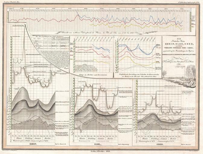
| Keywords: 1838 Perthes Chart of the Rhine, Elbe, and Order Rivers - Geographicus - RheinElbeOder-perthes-1838.jpg This is an unusual 1838 statistical chart by H Berghaus Offers a wealth of statistical information on the Rhine Elbe and Oder Rivers Published as part of Berghaus's Physikalischer Atlas a monumental work that evolved out of the 19th century's obsession with the collection and organization of raw data Beautifully produced in the 19th century with beautiful delicate engraving work high quality woven paper and precise but minimalist color work 1838 dated Size in 17 13 object history credit line accession number RheinElbeOder-perthes-1838 Berghaus H <i>Dr Heinrich Berghaus' Physikalischer Atlas oder Sammlung von Karten auf denen die hauptsachlichsten Erscheinungen der anorganischen und organischen Natur nach ihrer geographischen Verbreitung und Vertheilung bildlich dargestellt sind 1838 </i> 1838 Geographicus-source PD-old-100 Rhine in Cologne Pegelstände Oder River Küstrin Pegel Elbe in Dresden Pegelstände Elbe in Magdeburg Pegelstände Diagrams of the Elbe Pegelstände Statistical charts Perthes Pegelstände River-related diagrams Perthes Pegelstände 1838 engravings Perthes Pegelstände 19th-century diagrams Perthes Pegelstände History of statistics 1838 Pegelstände Geographic comparison diagrams Elbepegelstände | ||||