MAKE A MEME
View Large Image
| View Original: | 1834_S.D.U.K._Comparative_Map_or_Chart_of_the_World's_Great_Rivers_-_Geographicus_-_ComparativeRivers-sduk-1834.jpg (3000x3689) | |||
| Download: | Original | Medium | Small | Thumb |
| Courtesy of: | commons.wikimedia.org | More Like This | ||
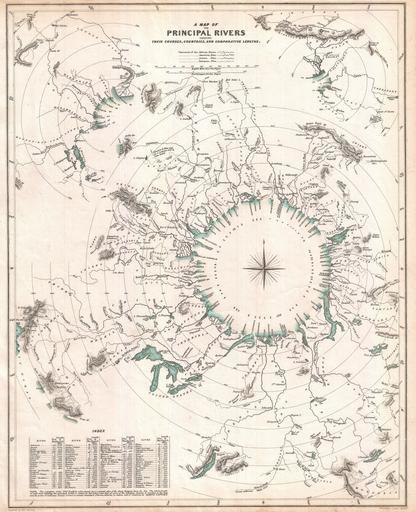
| Keywords: 1834 S.D.U.K. Comparative Map or Chart of the World's Great Rivers - Geographicus - ComparativeRivers-sduk-1834.jpg This curious comparative rivers chart published in 1834 by the Society for the Diffusion of Useful Knowledge is somewhat unique in that it imagines all of the great rivers of the world letting out into a circular inland sea Concentric circles show the general lengths of the rivers as the bird files but cannot take into account the twists and turns of the rivers themselves What this chart does show is to a degree the direction and course of the rivers' flow Direction which in other comparative rivers charts is indicated textually here is illustrated visually Nevertheless though innovative and physically attractive this S D U K comparative rivers chart never caught on beyond its initial publication Drawn by Baldwin and Craddock of 47 Paternoster Row London for the Society for the Diffusion of Useful Knowledge Atlas volume 1 Dated and copyrighted April 1 1834 1834 dated Size in 13 16 object history credit line accession number ComparativeRivers-sduk-1834 <i>Maps of the Society for the Diffusion of Useful Knowledge</i> Vol 1 London Chapman and Hall 186 Strand 1844 Geographicus-source PD-art Geographic comparison diagrams Society for the Diffusion of Useful Knowledge Great Britain River-related diagrams Old maps of rivers 1834 maps ImageNote 1 1848 1435 49 92 3000 3689 2 Dniepr ImageNoteEnd 1 | ||||