MAKE A MEME
View Large Image
| View Original: | 1833_Charle_Map_of_the_Dept._of_Morbihan,_Bretagne,_France_-_Geographicus_-_Morbihan-charle-1833.jpg (4000x2860) | |||
| Download: | Original | Medium | Small | Thumb |
| Courtesy of: | commons.wikimedia.org | More Like This | ||
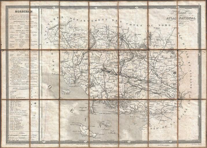
| Keywords: 1833 Charle Map of the Dept. of Morbihan, Bretagne, France - Geographicus - Morbihan-charle-1833.jpg A rare and very attractive 1833 map of the Morbihan region of Bretagne Breton or Brittany France Covers the entire Province from the Department de Finisterre to the Department de La Loire Morbihan is an exceptionally beautiful part of the Breton cost noted for its many islands many of which are now privately owned by movie stars politicians well known musicians and other influentials Morbihan is named for its most unusual feature a large inland sea near Vannes itself called The Morbihan This regions ia also the home of the mysterios megalithic ruins at Carnac This map was drawn by Charle and engraved by Dumortier as plate no 55 in Dauty and Roret ™s 1833 Nouvel Atlas National This departmental atlas of France was issued both bound as a book and as a collection of linen backed pocket format maps “ as seen here 1833 dated Size in 21 14 74 object history credit line accession number Morbihan-charle-1833 Charle J B L <i>NouvelAtlas National</i> 1833 Pocket Edition Geographicus-source PD-art Old maps of Morbihan 1833 maps | ||||