MAKE A MEME
View Large Image
| View Original: | 1827_Finley_Map_of_Egypt_-_Geographicus_-_Egypt-finley-1827.jpg (2318x3000) | |||
| Download: | Original | Medium | Small | Thumb |
| Courtesy of: | commons.wikimedia.org | More Like This | ||
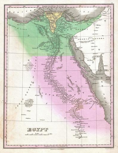
| Keywords: 1827 Finley Map of Egypt - Geographicus - Egypt-finley-1827.jpg A beautiful example of Finley's important 1827 map of Egypt Depicts Egypt centered on the Nile River and extending south as far as Aswan Names numerous settlements and villages along the course of the river including a number of temples and ancient Egyptian ruins Also identifies several desert Oases including Parva Kharga and Shekh Huled Dakhla In the Sinai Peninsula a mountain labeled Gebel Tour Mt Sinai or Horeb is drawn Title and scale in lower left quadrant Engraved by Young and Delleker for the 1827 edition of Anthony Finley's General Atlas 1827 undated Size in 9 11 5 object history credit line accession number Egypt-finley-1827 Finley Anthony <i>A New General Altas Comprising a Complete Set of Maps representing the Grand Divisions of the Globe Together with the several Empires Kingdoms and States in the World; Compiled from the Best Authorities and corrected by the Most Recent Discoveries</i> Philadelphia 1827 Geographicus-source PD-old-100 Anthony Finley Maps by Anthony Finley 1827 maps Old maps of Egypt 1827 in Egypt map | ||||