MAKE A MEME
View Large Image
| View Original: | 1827_Finley_Map_of_Canada_(Ontario,_Quebec)_-_Geographicus_-_Canada-finley-1827.jpg (3000x2317) | |||
| Download: | Original | Medium | Small | Thumb |
| Courtesy of: | commons.wikimedia.org | More Like This | ||
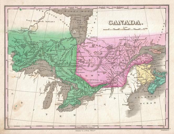
| Keywords: 1827 Finley Map of Canada (Ontario, Quebec) - Geographicus - Canada-finley-1827.jpg This is Finley ™s desirable 1827 map of Canada Covers the Upper Canada Ontario and Lower Canada Quebec New Brunswick Nova Scotia and all five of the Great Lakes Names numerous American Indian Nations throughout Also identifies the Three Rivers or Trois-Rivières is also noted Three Rivers was a primarily French administrative region in Quebec established in the 18th century Mile scale and title in the upper right quadrant Engraved by Young and Delleker for the 1827 edition of Anthony Finley's General Atlas 1827 undated Size in 11 5 9 object history credit line accession number Canada-finley-1827 Finley Anthony <i>A New General Altas Comprising a Complete Set of Maps representing the Grand Divisions of the Globe Together with the several Empires Kingdoms and States in the World; Compiled from the Best Authorities and corrected by the Most Recent Discoveries</i> Philadelphia 1827 Geographicus-source PD-old-100 Maps by Anthony Finley Old maps of Canada Old maps of the Great Lakes 1827 maps Maps in English | ||||
_-_Geographicus_-_Canada-finley-1827.jpg)