MAKE A MEME
View Large Image
| View Original: | 1818_Pinkerton_Map_of_Turkey_in_Europe,_Greece_andamp,_the_Balkans_-_Geographicus_-_TurkeyEurope2-pinkerton-1818.jpg (3631x5000) | |||
| Download: | Original | Medium | Small | Thumb |
| Courtesy of: | commons.wikimedia.org | More Like This | ||
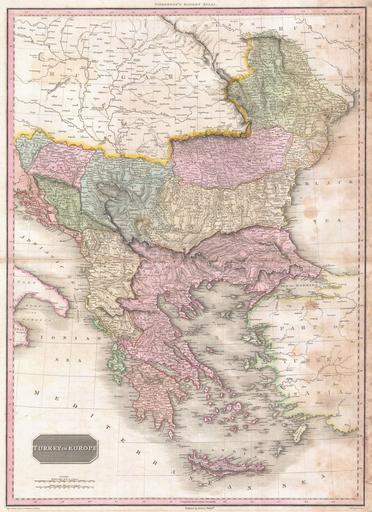
| Keywords: 1818 Pinkerton Map of Turkey in Europe, Greece andamp, the Balkans - Geographicus - TurkeyEurope2-pinkerton-1818.jpg Pinkerton's extraordinary 1818 map of the Turkey in Europe Covers the Ottoman Empire's holdings in Europe at the beginning of the 19th century Includes Greece Albania Macedonia Bosnia Croatia Bulgaria Rumania and Moldova Offers considerable detail with political divisions and color coding at the regional level Identifies cities towns castles important battle sites castles swamps mountains and river ways Title plate in the lower left quadrant Two mile scales in Turkish Miles and British Statute Miles also appear in the lower left quadrant Drawn by L Herbert and engraved by Samuel Neele under the direction of John Pinkerton This map comes from the scarce American edition of Pinkerton ™s Modern Atlas published by Thomas Dobson Co of Philadelphia in 1818 1818 undated Size in 20 28 5 object history credit line accession number TurkeyEurope2-pinkerton-1818 Pinkerton J <i>A Modern Atlas from the Lates and Best Authorities Exhibiting the Various Divisions of the World with its chief Empires Kingdoms and States; in Sixty Maps carefully reduced from the Larges and Most Authentic Sources </i> 1818 Philadelphia Thomas Dobson Edition Geographicus-source PD-old-100 Maps by John Pinkerton 19th-century maps of the Balkans 1818 maps Old Administrative Maps of the Ottoman Empire Old maps of Turkey Maps in English | ||||