MAKE A MEME
View Large Image
| View Original: | 1818_Pinkerton_Map_of_British_North_America_or_Canada_-_Geographicus_-_Canada-pinkerton-1818.jpg (5000x3648) | |||
| Download: | Original | Medium | Small | Thumb |
| Courtesy of: | commons.wikimedia.org | More Like This | ||
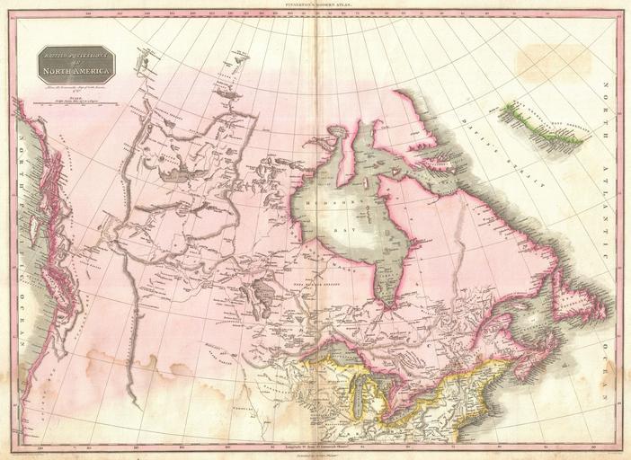
| Keywords: 1818 Pinkerton Map of British North America or Canada - Geographicus - Canada-pinkerton-1818.jpg Pinkerton's extraordinary 1818 map of the British Possessions in North America Based on Arrowsmith's historic map of North America this map covers the continent north of the 40th degree of latitude including all of the territory currently claimed by Canada This fascinating map follows roughly 100 years of vigorous exploration of this region by adventurers in search of a navigable river and lake route from the Great Lakes to the Pacific And yet even after all of this exploration much of the territory remains vague and uncertain Details numerous river systems and lakes some real some fictional between the Hudson Bay and the Rocky Mountains Offers copious notations throughout such as great quantities of coal in this creek and Knistineaux war route Shows the Missouri River as far as the Mandan settlements where Louis and Clark wintered Though the official narrative of Louis and Clark's historic journey had not been published when this map was in production it is possible that Pinkerton had access to some preliminary accounts Names several sightings of the Arctic Sea far to the north by the explorers Mackenzie and Hearne in the 18th century The west coast including Vancouver Islands is particularly well mapped Also notes numerous American Indian nations including the Knisteneaux Cree Blood Cattanahowes Snake Assinpolls Snake Atnah etc Drawn by L Herbert and engraved by Samuel Neele under the direction of John Pinkerton This map comes from the scarce American edition of Pinkerton ™s Modern Atlas published by Thomas Dobson Co of Philadelphia in 1818 1818 undated Size in 27 5 20 object history credit line accession number Canada-pinkerton-1818 Pinkerton J <i>A Modern Atlas from the Lates and Best Authorities Exhibiting the Various Divisions of the World with its chief Empires Kingdoms and States; in Sixty Maps carefully reduced from the Larges and Most Authentic Sources </i> 1818 Philadelphia Thomas Dobson Edition Geographicus-source PD-old-100 Maps by John Pinkerton Old maps of North America 1818 maps Maps in English | ||||