MAKE A MEME
View Large Image
| View Original: | 1814_Thomson_Map_of_Northern_India_and_Nepal_-_Geographicus_-_IndiaNepal-t-1814.jpg (3300x2752) | |||
| Download: | Original | Medium | Small | Thumb |
| Courtesy of: | commons.wikimedia.org | More Like This | ||
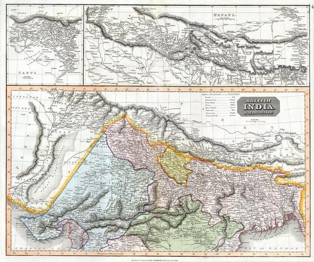
| Keywords: 1814 Thomson Map of Northern India and Nepal - Geographicus - IndiaNepal-t-1814.jpg This fascinating hand colored 1814 map by Edinburgh cartographer John Thomson depicts northern India and Nepal Bounded on the east by Persia and the Indus valley on the North by Tibet on the south by Berar and on the east by Assam and Bhutan Much of the upper portion of this map includes a detailed inset of the Kingdom of Nepal or Nepaul This area is depicted in impressive detail considering that when this map was printed very few western travelers had ever been to Nepal Includes roads mountain passes and the residences of important Lamas Extends fully into the Tibetan plateau as far as Te Shoo Loomboo and the Road to Lhasa Lassa The right hand corner of this map contains an inset of Kabul or Cabul 1814 Size in 25 20 object history credit line accession number IndiaNepal-t-1814 Geographicus-source PD-old-100 Maps by John Thomson Old maps of North India Old maps of Nepal Old maps of Pakistan 1814 maps of India 1814 in Nepal | ||||