MAKE A MEME
View Large Image
| View Original: | 1799_Cruttwell_Map_of_the_World_in_Hemispheres_-_Geographicus_-_WorldHemisphere-cruttwell-1799.jpg (3500x2387) | |||
| Download: | Original | Medium | Small | Thumb |
| Courtesy of: | commons.wikimedia.org | More Like This | ||
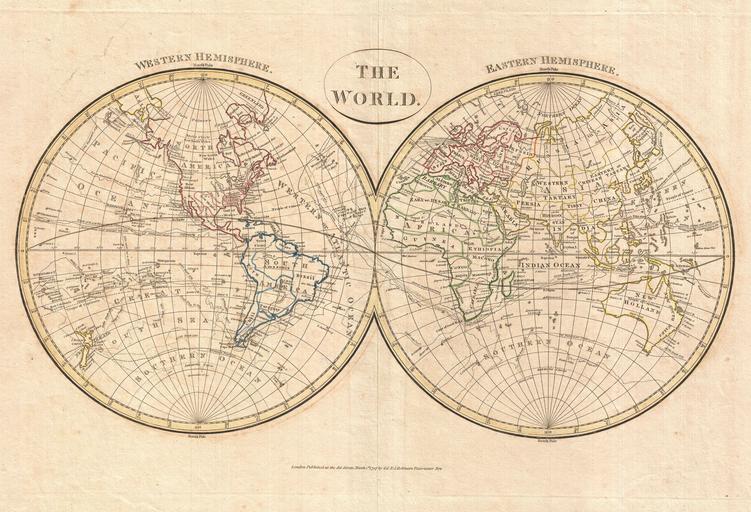
| Keywords: 1799 Cruttwell Map of the World in Hemispheres - Geographicus - WorldHemisphere-cruttwell-1799.jpg A fine example of Clement Cruttwell's 1799 map of the world in two hemispheres This is an elegant world map designed to illustrate the activities of important explorers of the 17th and18th centuries The tracks of Cook Anson Bourgainville Wallis Furneaux and others are noted Cook's work in the late 18th century being of extreme importance is emphasized Cartographically this map follows established convention but does feature the most recent discoveries of Cook and Vitus Bering in the Arctic Inland detail is somewhat minimal and focuses on important cities and countries There are a few anomalies worthy of note Tasmania is attached to the Australian mainland The southern shores of New Guinea are unknown and left blank Japan is incorrectly aligned along the horizontal The Sea between Japan and Korea the name of which is currently being disputed between Korea and Japan is here identified as the Sea of Corea In North America the apocryphal River of the West runs from the west coast inland Also in North America though the discoveries of Hearne are noted the work of MacKenzie further west is missing possibly Cruttwell was an investor in the Hudson Bay Company and didn't want to recognize the work of MacKenzie and the rival North West Company Antarctica which has not yet been discovered is absent The whole exhibits delicate outline color and fine copper plate engraving in the minimalist English style prevalent in the late 18th and early 19th centuries Drawn by G G and J Robinson of Paternoster Row London for Clement Cruttwell's 1799 Atlas to Cruttwell's Gazetteer 1799 dated Size in 18 11 object history credit line accession number WorldHemisphere-cruttwell-1799 Cruttwell C <i>Atlas to Cruttwell's Gazetteer</i> 1799 Geographicus-source PD-Art-100 Maps by Clement Cruttwell 1799 maps Old maps of Earth's hemispheres | ||||