MAKE A MEME
View Large Image
| View Original: | 1799_Clement_Cruttwell_Map_of_Holland_or_the_Netherlands_-_Geographicus_-_Batavia-cruttwell-1799.jpg (3500x3006) | |||
| Download: | Original | Medium | Small | Thumb |
| Courtesy of: | commons.wikimedia.org | More Like This | ||
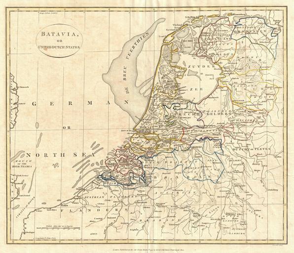
| Keywords: 1799 Clement Cruttwell Map of Holland or the Netherlands - Geographicus - Batavia-cruttwell-1799.jpg A fine 1799 map of Batavia or the United Dutch States the Netherlands by the English map publisher Clement Cruttwell Map is highly detailed with counties and municipalities outlined Of note on this particular map are the canals and dikes Cruttwell labeled These are extremely important to the country as two thirds of the land is vulnerable to flooding River dikes prevent flooding from water flowing into the country by the major rivers Rhine and Meuse while a system of drainage ditches canals and pumping stations windmills keep the low lying parts dry for habitation and agriculture The Beemster as Cruttwell notes in Northern Holland was the first of these and was reclaimed from a lake the water having been extracted by windmills He also labels what is known as the De Breeveertien De Bree Veerthien a large offshore shoal in the North Sea now home to an important wind farm In North Holland he identifies Zuyder Zee which at this point in time was a shallow bay in the North Sea In the 20th century the majority of the Zuyder Zee was closed off and the salt water inlet changed into a fresh water lake called the Ijsselmeer IJssel-lake named thus after the river that drains into it The whole offers hand color and fine copper plate engraving in the minimalist English style prevalent in the late 18th and early 19th centuries Drawn by G G and J Robinson of Paternoster Row London for Clement Cruttwell's 1799 Atlas to Cruttwell's Gazetteer 1799 dated Size in 16 5 14 object history credit line accession number Batavia-cruttwell-1799 Cruttwell C <i>Atlas to Cruttwell's Gazetteer</i> 1799 Geographicus-source PD-Art-100 Maps by Clement Cruttwell Old maps of the Netherlands 1799 maps | ||||