MAKE A MEME
View Large Image

| View Original: | 1794_Laurie_and_Whittle_Map_of_Greece,_Turkey_andamp,_the_Balkans_-_Geographicus_-_TurkeyEurope-lauriewhittle-1794.jpg (4000x3979) | |||
| Download: | Original | Medium | Small | Thumb |
| Courtesy of: | commons.wikimedia.org | More Like This | ||
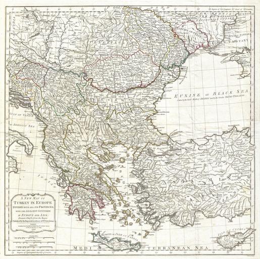
| Keywords: 1794 Laurie and Whittle Map of Greece, Turkey andamp, the Balkans - Geographicus - TurkeyEurope-lauriewhittle-1794.jpg An extraordinary large format 1794 map of Greece Turkey in Europe the Balkans and adjacent regions by Laurie and Whittle Map covers from the Gulf of Taranto Italy eastward as far as the Crimea extend northwards to Transylvania and Moldova and southwards as far as Crete and Cyprus Includes the modern day nations of Greece Turkey Cyprus Bosnia Croatia Albania Serbia Macedonia Bulgaria Hungary Rumania Bulgaria Moldova and parts of Italy Austria and the Ukraine Offers extraordinary detail throughout noting cities roads geographical features and sub-states Based on survey work originally completed in 1789 by the Imperial Academy of Sciences in St Petersburg Prepared and published by Laurie and Whittle as plate no 24 in the 1797 edition of Thomas Kitchin's General Atlas 1794 dated Size in 24 5 24 5 object history credit line accession number TurkeyEurope-lauriewhittle-1794 Kitchin Thomas <i>Kitchin's General Atlas describing the Whole Universe being a complete collection of the most approved maps extant; corrected with the greatest care and augmented from the last edition of D'Anville and Robert with many improvements by other eminent geographers engraved on Sixty-Two plates comprising Thirty Seven maps </i> Laurie Whittle London 1797 Geographicus-source PD-Art-100 18th-century maps of the Balkans Old maps of the Ottoman Empire 1794 maps | ||||