MAKE A MEME
View Large Image
| View Original: | 1764_Bellin_Map_of_Bombay_(Mumbai)_India_-_Geographicus_-_Bombay-bellin-1750.jpg (2099x2705) | |||
| Download: | Original | Medium | Small | Thumb |
| Courtesy of: | commons.wikimedia.org | More Like This | ||
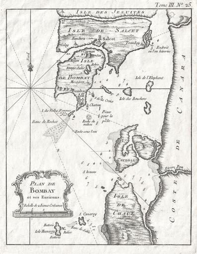
| Keywords: 1764 Bellin Map of Bombay (Mumbai) India - Geographicus - Bombay-bellin-1750.jpg An extremely attractive and rare 1764 map of Bombay or Mumbai India by J N Bellin Depicted the peninsula of Bombay as it was in the 1700s “ divided into several small islands including Salcet Bombay and the Isle of the Jesuits Shows the city and fort of Bombay at the southern tip of Bombay Island Also shows the villages of Salcet Cayman Mayen Colay Bandura and Trombay Includes the coast of mainland India from the Negalan River northward past the River Penn to what is today Panvel Creek Offers considerable offshore detail including depth soundings around Bombay Harbor and references to shoals and anchorage Decorative title cartouche in the baroque style in the lower left quadrant Prepared by J N Bellin for issued as Map no 25 in vole III of the 1864 issue of Le Petit Atlas Maritime 1764 undated Size in 9 7 object history credit line accession number Bombay-bellin-1750 Bellin J N <i>Le Petit Atlas Maritime Recueil de cartes et plans des quatre parties du monde </i> Volume III of the 1764 edition Geographicus-source PD-old-100 Old maps of Mumbai 1764 maps of India Maps by Jacques-Nicolas Bellin | ||||
_India_-_Geographicus_-_Bombay-bellin-1750.jpg)