MAKE A MEME
View Large Image
| View Original: | 1761_Homann_Heirs_Map_of_Westphalia_(_Bremen,_Hamburg,_Cologne,_Bonn,_etc._)_-_Geographicus_-_Westphaliae-hmhr-1761.jpg (4354x5000) | |||
| Download: | Original | Medium | Small | Thumb |
| Courtesy of: | commons.wikimedia.org | More Like This | ||
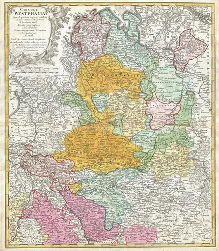
| Keywords: 1761 Homann Heirs Map of Westphalia ( Bremen, Hamburg, Cologne, Bonn, etc. ) - Geographicus - Westphaliae-hmhr-1761.jpg A beautifully detailed c 1761 Homann Heirs map of Westphalia Covers from Bremen and Hamburg in the north to Cologne Bonn Dusseldorf Aix Wyck and Luttich in the south Arnheim Nimmegen Wesel Munster Minden Cassel Hannover and Meppen also shown The map details fortified cities villages roads bridges forests castles and topography The title cartouche in the upper left quadrant features a cherubic child frolicking This map was drawn in Nuremberg and included in the c 1760 edition of Homann Heirs Maior Atlas Scholasticus ex Triginta Sex Generalibus et Specialibus ¦ 1761 dated Size in 19 25 22 5 object history credit line accession number Westphaliae-hmhr-1761 <i>Major Atlas Scholasticus Ex Triginta sex Generalibus et Specialibus Mappis Homannianis </i> c 1760 Geographicus-source PD-Art-100 Maps by Homannsche Erben Old maps of Westphalia 1761 maps Maps in Latin North Rhine-Westphalia in the 18th century | ||||
_-_Geographicus_-_Westphaliae-hmhr-1761.jpg)