MAKE A MEME
View Large Image
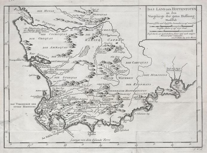
| View Original: | 1757_Bellin_Map_of_South_Africa_and_the_Cape_of_Good_Hope_-_Geographicus_-_Hottentoten-bellin-1757.jpg (4137x3055) | |||
| Download: | Original | Medium | Small | Thumb |
| Courtesy of: | commons.wikimedia.org | More Like This | ||
| Keywords: 1757 Bellin Map of South Africa and the Cape of Good Hope - Geographicus - Hottentoten-bellin-1757.jpg A very scarce example of Bellin ™s 1747 map of southern Africa and the Cape of Good Hope Covers from the Bay of St Helena to Mussel Bay Dutch settlements appear along the coast line with African tribal regions dominating the interior Features excellent geographical detail referencing swamps mountains forests and rivers While the French edition of this map appears with some regularity this the German edition is extremely rare Compared to the French and Italian editions it is printed on much heavier stock and has a much darker impression From the German edition of Provost ™s Voyages edited and published by Johann Joachim Schwabe Allgemeine Historie der Reisen zu Wasser und zu Lande General History of Travel over Water and Land circa 1747 undated Size in 13 5 9 5 object history credit line accession number Hottentoten-bellin-1757 Johann Joachim Schwabe <i>Allgemeine Historie der Reisen zu Wasser und zu Lande</i> c 1747 Geographicus-source PD-old-100 Old maps of South Africa 1747 maps Cape of Good Hope Maps in German Maps by Jacques-Nicolas Bellin Rivers of South Africa | ||||