MAKE A MEME
View Large Image
| View Original: | 1750_Homann_Heirs_Map_of_Israel_-_Palestine_-_Holy_Land_(12_Tribes)_-_Geographicus_-_Palestina-homannheirs-1750.jpg (4000x3622) | |||
| Download: | Original | Medium | Small | Thumb |
| Courtesy of: | commons.wikimedia.org | More Like This | ||
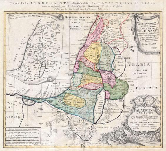
| Keywords: 1750 Homann Heirs Map of Israel - Palestine - Holy Land (12 Tribes) - Geographicus - Palestina-homannheirs-1750.jpg This is one of the Homann Heirs finest and most appealing maps of Palestine / Israel / The Holy Land Depicts the region divided into the 12 Tribes of Israel In the right hand corners there are two title cartouches The lower is exceptionally decorative and depicts with two spies of Moses bearing the fruit from the Promised Land to the Hebrew camp as well as the front and back of an ancient shekel coin The upper left quadrant offers an overview of the region as a whole The upper right features a dedication from the mapmaker to Karl Wilhelm Ferdinand the future Duke of Braunschweig-WolfenbĂĽttel and Braunschweig-LĂĽneburg from 1773 This map was drawn by Johann Christoph Harenberg for inclusion the 1752 Homann Heirs Maior Atlas Scholasticus ex Triginta Sex Generalibus et Specialibus ¦ Most early Homann atlases were made to order or compiled of individual maps at the request of the buyer However this rare atlas composed of 37 maps and charts was issued as a suggested collection of essential Homann Heirs maps A fine copy of an important map 1750 Size in 21 19 object history credit line accession number Palestina-homannheirs-1750 Geographicus-source PD-Art-100 Maps by Homannsche Erben Old maps of the Holy Land 1750 maps Old maps of Israel Old maps of Palestine Johann Christoph Harenberg Maps of the Tribes of Israel | ||||
_-_Geographicus_-_Palestina-homannheirs-1750.jpg)