MAKE A MEME
View Large Image
| View Original: | 1750_Bellin_Map_of_the_Senegal_-_Geographicus_-_Senegal-bellin-1750.jpg (1985x2784) | |||
| Download: | Original | Medium | Small | Thumb |
| Courtesy of: | commons.wikimedia.org | More Like This | ||
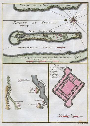
| Keywords: 1750 Bellin Map of the Senegal - Geographicus - Senegal-bellin-1750.jpg This stunning 1747 nautical chart by French mapmaker J C Bellin the Elder depicts the Senegal River and the area surrounding Fort St Joseph Fort St Louis This region was part of the Senegambia the Company of the Indies Senegal Concession It was from this port that the French company shipped hundreds of African slaves to its colonies in Louisiana Today the Senegal River forms the important border between Senegal and Mauritania This beautiful map depicts individual buildings trees and even tiny villages There is a detailed plan of Fort St Joseph 1750 Size in 9 6 5 object history credit line accession number Senegal-bellin-1750 Geographicus-source PD-old-100 Old maps of Saint-Louis Senegal 1750 maps Slavery-related maps Senegal River Maps by Jacques-Nicolas Bellin Slavery in Islam | ||||