MAKE A MEME
View Large Image
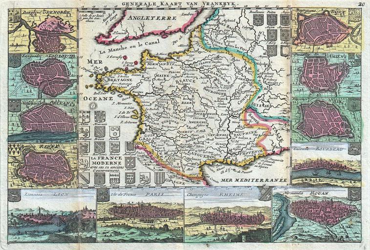
| View Original: | 1747_La_Feuille_Map_of_France_-_Geographicus_-_France-ratelband-1747.jpg (2500x1691) | |||
| Download: | Original | Medium | Small | Thumb |
| Courtesy of: | commons.wikimedia.org | More Like This | ||
| Keywords: 1747 La Feuille Map of France - Geographicus - France-ratelband-1747.jpg A stunning map of France first drawn by Daniel de la Feuille in 1706 Depicts all of France as well as parts of Italy England Spain Switzerland Belgium and Germany Flanked on either side and along the bottom by plans and views of important French cities From top left these include Grenoble Loulouzf Orleans Renne Rennes Lion Paris Rheims Rouan Rouen Bourdeau Bordeaux Aix Amiens and Dijon Title cartouche in the lower left quadrant surrounded by the armorial crests of seventeen important French regions An additional seven crests appear in the upper right quadrant Alternate Dutch language title in upper margin This is Paul de la Feuille ™s 1747 reissue of his father Daniel ™s 1706 map Prepared for issue as plate no 25 in J Ratelband ™s 1747 Geographisch-Toneel 1747 undated Size in 10 25 7 object history credit line accession number France-ratelband-1747 <i>Geographisch-Toneel Of uitgezochte Kaarten Tot gemak der Officieren Reisigers en Liefhebbers; Behelsende alle de generale Kaarten </i> 1747 J Ratelband issue Geographicus-source PD-old-100 Daniel de La Feuille Old maps of the history of France 1747 maps France Maps in French France | ||||