MAKE A MEME
View Large Image
| View Original: | 1747_La_Feuille_Map_of_Holland_-_Geographicus_-_Holland-lafeuille-1747.jpg (3000x1932) | |||
| Download: | Original | Medium | Small | Thumb |
| Courtesy of: | commons.wikimedia.org | More Like This | ||
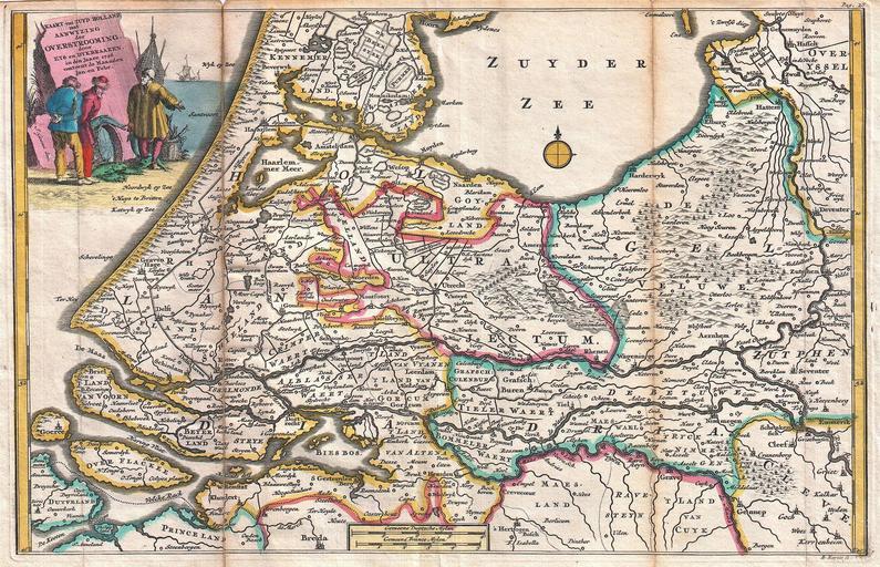
| Keywords: 1747 La Feuille Map of Holland - Geographicus - Holland-lafeuille-1747.jpg A stunning map of Holland first drawn by Daniel de la Feuille in 1706 Depicts Holland south of Amsterdam focusing and the delta and course of the Rhine River A title cartouche in the upper left quadrant drawn by J Goeree features three fishermen discussing the day ™s catch This is Paul de la Feuille ™s 1747 reissue of his father Daniel ™s 1706 map Prepared for issue as plate no 2 in J Ratelband ™s 1747 Geographisch-Toneel 1747 dated 1726 Size in 12 7 75 object history credit line accession number Holland-lafeuille-1747 <i>Geographisch-Toneel Of uitgezochte Kaarten Tot gemak der Officieren Reisigers en Liefhebbers; Behelsende alle de generale Kaarten </i> 1747 J Ratelband issue Geographicus-source PD-old-100 1726 maps Netherlands Old maps of the Netherlands 1726 Maps in Dutch Netherlands Daniel de La Feuille Netherlands Jan Goeree | ||||