MAKE A MEME
View Large Image
| View Original: | 1747_La_Feuille_Map_of_Liege,_Belgium_(_Leodiensis)_-_Geographicus_-_Leodiensis-lafeuille-1747.jpg (2500x1783) | |||
| Download: | Original | Medium | Small | Thumb |
| Courtesy of: | commons.wikimedia.org | More Like This | ||
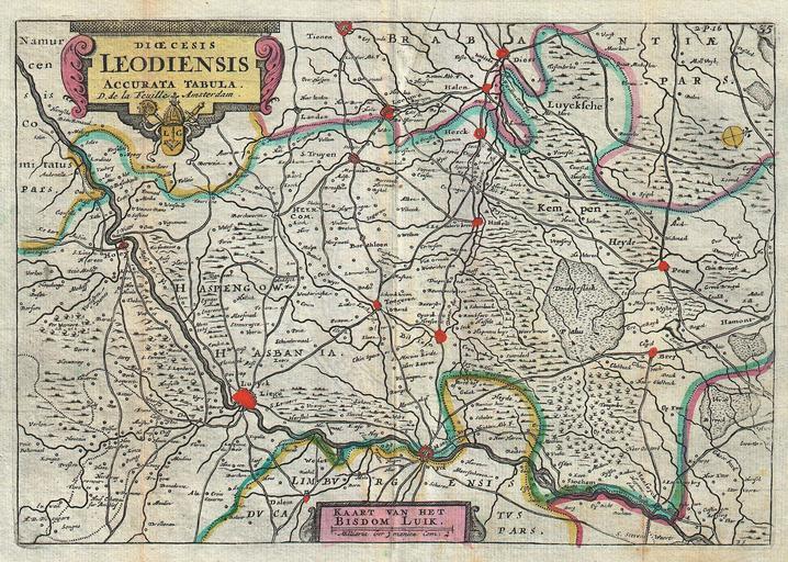
| Keywords: 1747 La Feuille Map of Liege, Belgium ( Leodiensis) - Geographicus - Leodiensis-lafeuille-1747.jpg A stunning map of Leodiensis or the vicinity of Liege Belgium first drawn by Daniel de la Feuille in 1706 Depicts from Hoey in the west eastward as far as Peer southward as far as Dalem and northwards as far as Tienen Latin title cartouche in the upper left quadrant features baroque decorations and an armorial crest Dutch titlearea at bottom center This is Paul de la Feuille ™s 1747 reissue of his father Daniel ™s 1706 map Prepared for issue as plate no 39 in J Ratelband ™s 1747 Geographisch-Toneel 1747 undated Size in 10 25 7 object history credit line accession number Leodiensis-lafeuille-1747 <i>Geographisch-Toneel Of uitgezochte Kaarten Tot gemak der Officieren Reisigers en Liefhebbers; Behelsende alle de generale Kaarten </i> 1747 J Ratelband issue Geographicus-source PD-old-100 Daniel de La Feuille Belgium Old maps of Belgium Maps of Liège in the 18th century 1747 maps Belgium Maps in Latin Belgium | ||||
_-_Geographicus_-_Leodiensis-lafeuille-1747.jpg)