MAKE A MEME
View Large Image
| View Original: | 1747_La_Feuille_Map_of_Hungary_-_Geographicus_-_Hongrie-lafeuille-1747.jpg (2500x1733) | |||
| Download: | Original | Medium | Small | Thumb |
| Courtesy of: | commons.wikimedia.org | More Like This | ||
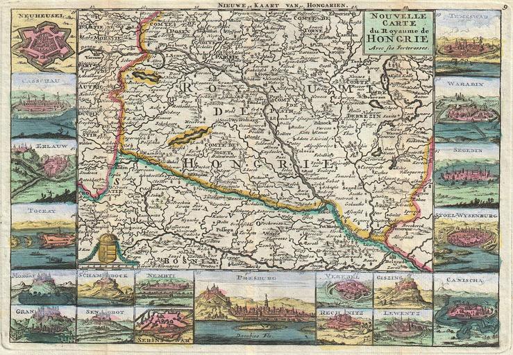
| Keywords: 1747 La Feuille Map of Hungary - Geographicus - Hongrie-lafeuille-1747.jpg A stunning map of Hungary first drawn by Daniel de la Feuille in 1706 Covers from Moravia in the northwest south to Bosnia and east as far as Belgrade Surrounded by twenty maps and views of important villages and fortresses in this region From top right in a clockwise fashion these include Temeswar Waradin Segedin Stoel-Wysenburg Canischa Giszing Lewentz Rechnitz Vererel Presburg Nembti Serinswar Sengrot Schambock Gran Mongat Tockay Erlauw Casschau and Neuheusel French language title in the upper right hand quadrant Alternate Dutch language title along the upper border This is Paul de la Feuille ™s 1747 reissue of his father Daniel ™s 1706 map Prepared for issue as plate no 9 in J Ratelband ™s 1747 Geographisch-Toneel 1747 undated Size in 10 25 7 object history credit line accession number Hongrie-lafeuille-1747 <i>Geographisch-Toneel Of uitgezochte Kaarten Tot gemak der Officieren Reisigers en Liefhebbers; Behelsende alle de generale Kaarten </i> 1747 J Ratelband issue Geographicus-source PD-old-100 Daniel de La Feuille Hungary Old maps of Hungary 1747 1747 maps Hungary Maps in French Hungary | ||||