MAKE A MEME
View Large Image
| View Original: | 1747_La_Feuille_Map_of_Catalonia,_Spain_(Barcelona)_-_Geographicus_-_Catalogne-ratelband-1747.jpg (2500x1703) | |||
| Download: | Original | Medium | Small | Thumb |
| Courtesy of: | commons.wikimedia.org | More Like This | ||
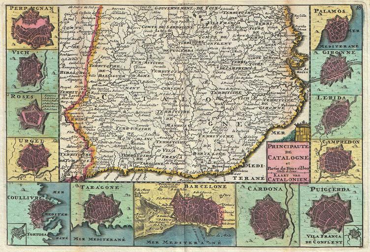
| Keywords: 1747 La Feuille Map of Catalonia, Spain (Barcelona) - Geographicus - Catalogne-ratelband-1747.jpg A stunning map of Catalonia Spain first drawn by Daniel de la Feuille in 1706 Surrounded by thirteen city plans From top right in an anti-clockwise fashion these include Perpignan Vich Roses Irgel Coullivre Taragone Tarragona Barcelone Barcelona Cardona Puigcerda Campredon Lerida Gironne and Palamos Title cartouche in the lower right quadrant features title in both Dutch and French surmounted by the armorial crest of Catalonia This is Paul de la Feuille ™s 1747 reissue of his father Daniel ™s 1706 map Prepared for issue as plate no 20 in J Ratelband ™s 1747 Geographisch-Toneel 1747 undated Size in 10 25 7 object history credit line accession number Catalogne-ratelband-1747 <i>Geographisch-Toneel Of uitgezochte Kaarten Tot gemak der Officieren Reisigers en Liefhebbers; Behelsende alle de generale Kaarten </i> 1747 J Ratelband issue Geographicus-source PD-old-100 Daniel de La Feuille Spain Old maps of Catalonia 1747 maps Spain Maps in French Spain Coats of arms of Catalonia | ||||
_-_Geographicus_-_Catalogne-ratelband-1747.jpg)