MAKE A MEME
View Large Image
| View Original: | 1747_La_Feuille_Map_of_South_America_-_Geographicus_-_SouthAmerica-ratelband-1747.jpg (2000x1517) | |||
| Download: | Original | Medium | Small | Thumb |
| Courtesy of: | commons.wikimedia.org | More Like This | ||
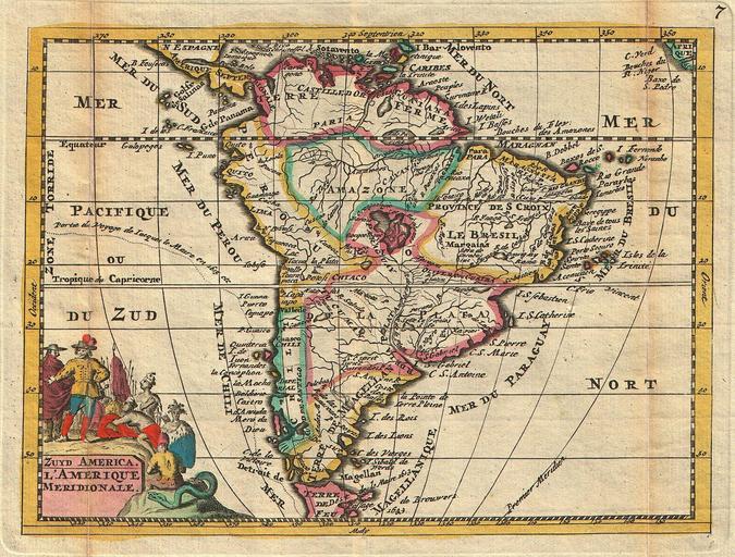
| Keywords: 1747 La Feuille Map of South America - Geographicus - SouthAmerica-ratelband-1747.jpg A stunning map of South America first drawn by Daniel de la Feuille in 1706 Continent is represented according to the 18th century political geography Labels several important cities including Cusco Quito Lima San Sebastian and Cartagena Shows two large imaginary lakes in the interior Title cartouche in the lower left hand quadrant features stylized images of Native Americans offering gifts to Europeans while an enormous and eerily grinning serpent looks on Title in both Dutch and French This is Paul de la Feuille ™s 1747 reissue of his father Daniel ™s 1706 map Prepared for issue as plate no 7 in J Ratelband ™s 1747 Geographisch-Toneel 1747 undated Size in 7 5 6 object history credit line accession number SouthAmerica-ratelband-1747 <i>Geographisch-Toneel Of uitgezochte Kaarten Tot gemak der Officieren Reisigers en Liefhebbers; Behelsende alle de generale Kaarten </i> 1747 J Ratelband issue Geographicus-source PD-old-100 Daniel de La Feuille America south Old maps of South America 1747 1747 maps America south Maps in French America south | ||||