MAKE A MEME
View Large Image
| View Original: | 1747_Homann_Heirs_Map_of_Austria_and_Bohemia_(_Czech_Republic_)_-_Geographicus_-_Austriacus-hmhr-1747.jpg (5000x4363) | |||
| Download: | Original | Medium | Small | Thumb |
| Courtesy of: | commons.wikimedia.org | More Like This | ||
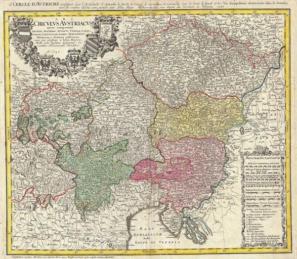
| Keywords: 1747 Homann Heirs Map of Austria and Bohemia ( Czech Republic ) - Geographicus - Austriacus-hmhr-1747.jpg A beautifully detailed 1747 Homann Heirs map of Austria and Bohemia Czech Republic Includes parts of Italy Switzerland Germany Croatia and Hungary The map is filled with information including fortified cities villages roads bridges forests castles and topography Elaborate title cartouche in the upper left quadrant features three cherubs and four armorial shields Austria Tyrolis Carniolia Carinthiaand Stiria This map was drawn in Nuremberg by Johann Tobias Mayer for inclusion the 1752 Homann Heirs Maior Atlas Scholasticus ex Triginta Sex Generalibus et Specialibus ¦ Most early Homann atlases were made to order or compiled of individual maps at the request of the buyer However this rare atlas composed of 37 maps and charts was issued as a suggested collection of essential Homann Heirs maps 1747 dated Size in 20 5 18 object history credit line accession number Austriacus-hmhr-1747 <i>Major Atlas Scholasticus Ex Triginta sex Generalibus et Specialibus Mappis Homannianis </i> 1752 Geographicus-source PD-Art-100 Maps by Homannsche Erben Old maps of Austria Old maps of Bohemia Maps in Latin 1747 maps | ||||
_-_Geographicus_-_Austriacus-hmhr-1747.jpg)