MAKE A MEME
View Large Image
| View Original: | 1741_Homann_Heirs_Map_of_France_-_Geographicus_-_France-hmhr-1741.jpg (5000x4491) | |||
| Download: | Original | Medium | Small | Thumb |
| Courtesy of: | commons.wikimedia.org | More Like This | ||
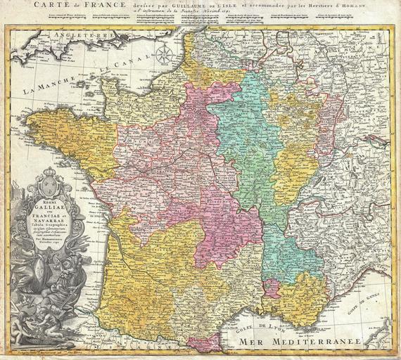
| Keywords: 1741 Homann Heirs Map of France - Geographicus - France-hmhr-1741.jpg A beautifully detailed 1741 Homann Heirs map of France based upon earlier work of Guillaume de L ™Isle Depicts the Kingdoms of France and Navarre along with parts of Italy Switzerland Spain and Germany The map notes fortified cities villages roads bridges forests castles and topography Elaborate title cartouche in the lower left quadrant features A bearded warrior with a sword hidden behind his back confronting a warrior woman with a gorgon shield Above this couple is a large baroque title area surmounted by the French royal crest Below the couple there are two children making wine Map scales in upper margin Alternative title in French in top margin above scales Carte de France dressee par Guillaume de L'Isle et accommodee par les Heritiers d'Homann a l'instruction de la Jeunesse Norimb 1741 This map was drawn in Nuremberg by J B Homann and included in the Homann Heirs Maior Atlas Scholasticus ex Triginta Sex Generalibus et Specialibus ¦ 1741 dated Size in 23 20 object history credit line accession number France-hmhr-1741 <i>Major Atlas Scholasticus Ex Triginta sex Generalibus et Specialibus Mappis Homannianis </i> c 1750 Geographicus-source PD-old-100 Maps by Homannsche Erben Old maps of the history of France 1741 maps Maps in Latin Johann Baptist Homann Administrative history of France | ||||