MAKE A MEME
View Large Image
| View Original: | 1730_Homann_Map_of_the_Upper_Rhine_(_Frankfurt,_Cassel,_Coblentz,_Darmstadt_)_-_Geographicus_-_RhenanusSuperior-homann-1730.jpg (5000x4279) | |||
| Download: | Original | Medium | Small | Thumb |
| Courtesy of: | commons.wikimedia.org | More Like This | ||
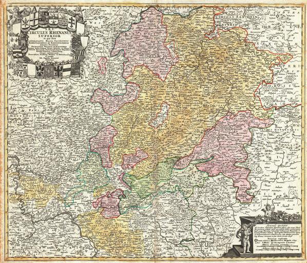
| Keywords: 1730 Homann Map of the Upper Rhine ( Frankfurt, Cassel, Coblentz, Darmstadt ) - Geographicus - RhenanusSuperior-homann-1730.jpg A beautifully detailed c 1730 Homann Heirs map of Upper Rhine region Covers from Coblentz eastward as far as Schweinfurt Schmalkalden and Mulhausen; northwards as far as Gottingen; and southwards as far as Darmstadt and Wertheim Includes the cities of Cassel Hirschfeld Fulda Frankfurt am Oder Darmstadt Nassaw and Marpurb The map details fortified cities villages roads bridges forests castles and topography The title cartouche in the upper left quadrant features twenty-one heraldic crests each representing a major city Curiously four are blank Legend with cherubs in lower right quadrant This map was drawn in Nuremberg by J B Homann and issued in Homann ™s Grosser Atlas as well as in the Homann Heirs ™ Maior Atlas Scholasticus ex Triginta Sex Generalibus et Specialibus ¦ circa 1730 undated Size in 22 75 19 25 object history credit line accession number RhenanusSuperior-homann-1730 <i>Major Atlas Scholasticus Ex Triginta sex Generalibus et Specialibus Mappis Homannianis </i> c 1750 / Also issued in Homann's <i>Grosser Atlas</i> Geographicus-source PD-old-100 Johann Baptist Homann Maps by Homannsche Erben Old maps of Hesse 1730 maps Maps in Latin | ||||
_-_Geographicus_-_RhenanusSuperior-homann-1730.jpg)