MAKE A MEME
View Large Image
| View Original: | 1729_Schryver_Map_of_Israel_showing_12_Tribes_-_Geographicus_-_Israel-schryver-1729.jpg (1667x3000) | |||
| Download: | Original | Medium | Small | Thumb |
| Courtesy of: | commons.wikimedia.org | More Like This | ||
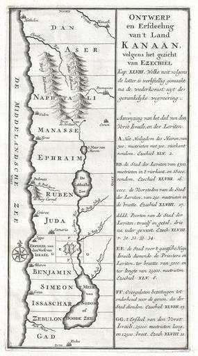
| Keywords: 1729 Schryver Map of Israel showing 12 Tribes - Geographicus - Israel-schryver-1729.jpg An extremely uncommon c 1729 map of ancient Israel Most likely drawn by the Dutch engraver Schryver this map shows Israel from Hethelon in the north to Kades just south of the Dead Sea Divided into the areas controlled by the Twelve Tribes of Israel from the north these are Dan Aser Naphtali Manasse Ephraim Ruben Juda Benjamin Simeon Issachar Zebulon and Gad Shows several important cities including Jerusalem Gaza Cezarea Caesarea Damascus Tyrus Tyre Joppe Jaffa near modern Tel Aviv etc The right side of the map is dedicated to Old Testament quotations mostly drawn from the Book of Ezekiel describing the region Probably issued in an early 18th century Dutch Bible or other Biblical reference circa 1729 undated Size in 8 14 object history credit line accession number Israel-schryver-1729 Geographicus-source PD-Art-100 Old maps of Israel 1729 maps Old maps of the Holy Land Maps in Dutch Biblical maps Maps of the Tribes of Israel | ||||