MAKE A MEME
View Large Image
| View Original: | 1721_Map_of_the_new_part_of_French_Louisiana.jpg (8104x6291) | |||
| Download: | Original | Medium | Small | Thumb |
| Courtesy of: | commons.wikimedia.org | More Like This | ||
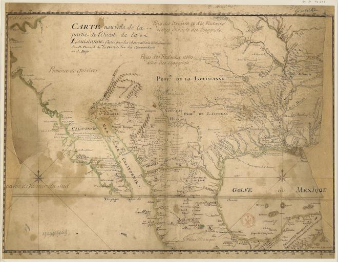
| Keywords: 1721 Map of the new part of French Louisiana.jpg LargeImage en Map of the new part of western French Louisiana / made ‹ ‹on the observations and findings of Mr Benard de La Harpe one of the commanders of Countries; Copied by Jean-Baptiste d'Anville fr Carte nouvelle de la partie de l'ouest de la Louisianne / faite sur les observations et dĂ©couvertes de M Benard de La Harpe l'un des commandants au d PaĂżs ; copiĂ©e par Jean-Baptiste d'Anville Institution Bibliothèque nationale de France 1721 Creator Jean Baptiste Bourguignon d'Anville based on observations by Jean-Baptiste BĂ©nard de la Harpe 1683-1765 PD-old-100 http //gallica bnf fr/ark /12148/btv1b530092504 Retouched picture Adjusted exposure settings for clarity scewing Old maps in the Bibliothèque nationale de France 1721 maps Jean-Baptiste BĂ©nard de la Harpe Old maps of New France Old maps of North America Old maps of California Old maps of Mexico 1721 in the United States Colonial Louisiana Old maps of Louisiana Old maps of the United States Old maps of Texas Old maps of New Mexico Old maps of Michigan Old maps of Illinois Old maps of Missouri Old maps of Oklahoma Old maps of Arkansas Old maps of Mississippi Old maps of Arizona Maps by Jean-Baptiste Bourguignon d'Anville | ||||