MAKE A MEME
View Large Image
| View Original: | 1720_Homann_Map_of_Franconia,_Germany_(_Bavaria,_Bamberg,_WĂĽrtzburg,_Nuremberg_)_-_Geographicus_-_Franconiae-homann-1720.jpg (4346x5000) | |||
| Download: | Original | Medium | Small | Thumb |
| Courtesy of: | commons.wikimedia.org | More Like This | ||
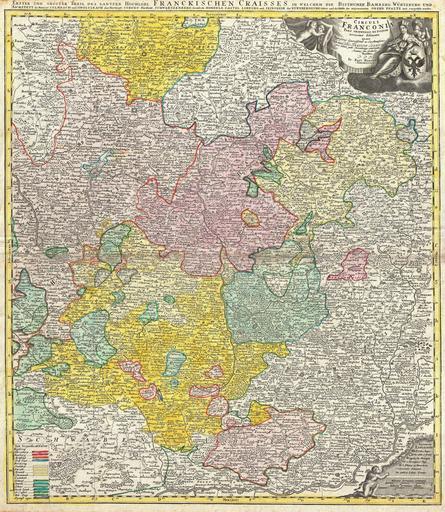
| Keywords: 1720 Homann Map of Franconia, Germany ( Bavaria, Bamberg, WĂĽrtzburg, Nuremberg ) - Geographicus - Franconiae-homann-1720.jpg A fine example of J B Homann ™s c 1720 map of Franconia Franken part of Bavaria Germany Centered on Bamberg WĂĽrtzburg and Nuremberg extending north as far as Gotha south to Swabia east to Mergentheim and east to Pfreimt Ober Pfalz The map is filled with information including fortified cities villages roads bridges forests battlefields castles and topography Title cartouche in the upper right quadrant features cherubs an enthroned queen with a castle-like crown and an armorial shield Legends in both the lower right and the lower left quadrants Additional title in German outside upper margin Erster und Groster Theil Des Gantzen Hochlobl Franckischen Craisses in welchem die Bisthumer Bamberg Wurtzburg und Aichstett Prepared in Nuremberg by J B Homann and issued in Homann Heirs ™ Maior Atlas Scholasticus circa 1720 undated Size in 19 5 22 5 object history credit line accession number Franconiae-homann-1720 <i>Major Atlas Scholasticus Ex Triginta sex Generalibus et Specialibus Mappis Homannianis </i> c 1730 / Also issued in Homann's <i>Grosser Atlas</i> Geographicus-source PD-old-100 Johann Baptist Homann Old maps of Bavaria 1720 maps Maps in Latin Maps in German Franconia | ||||
_-_Geographicus_-_Franconiae-homann-1720.jpg)