MAKE A MEME
View Large Image
| View Original: | 1688_Hennepin_First_Book_and_Map_of_North_America_(first_printed_map_to_name_Louisiana)_-_Geographicus_-_NieuwVrankryk-hennepin-1688.jpg (3070x4000) | |||
| Download: | Original | Medium | Small | Thumb |
| Courtesy of: | commons.wikimedia.org | More Like This | ||
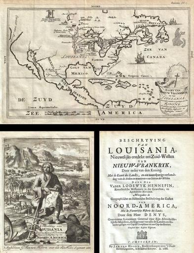
| Keywords: 1688 Hennepin First Book and Map of North America (first printed map to name Louisiana) - Geographicus - NieuwVrankryk-hennepin-1688.jpg Artwork de la Louisiane of which this is the first Dutch edition This book features a map that depicts much of the upper Mississippi valley but does not suggest exploration as far as the Gulf of Mexico “ as do Hennepin ™s two later maps This map is believed to be the first printed map made from actual observations to bear the name Louisiana In this work Hennepin claims to have coined the term Louisiane but it was in fact La Salle who had first named the region This edition of Hennepin's map features a curious title cartouche in the lower right quadrant intended to represent the triumph of Christianity in Louisiana The words Trumf van Louisiana surround a cross radiating the power of god A putto to the left of the cross supports a tapestry containing the title of the map 1688 dated Size in 11 5 7 5 object history credit line accession number NieuwVrankryk-hennepin-1688 Hennepin Louis <i>Beschryving van Louisania nieuwelijks ontdekt ten Zuid-Westen van Nieuw-Vrankrik door order van den Koning met de kaart des landts en een nauwkeurige verhandeling van de zeden en manieren van leeven der wilden door den Vader Lodewyk Hennepin </i> 1688 Jan Ten Hoorn Dutch Edition Geographicus-source de la Louisiane 17th-century maps of North America | ||||
_-_Geographicus_-_NieuwVrankryk-hennepin-1688.jpg)